FAQs and responses from the developer
I have met with Berkeley Homes and am continuing to fight to make sure this development does not negatively impact local people.
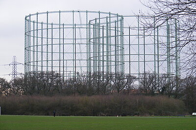
The proposed Berkeley Homes development of the Motspur Park Gasholders has been mentioned to me by dozens of residents by email, and in person at my recent street surgeries in Worcester Park.
This will ultimately be a decision for Kingston Council - where the development will take place. But its impact on Worcester Park is not something we can ignore - so I have been working to get the best out of this development for local residents. I am engaging with the developer and Sutton Council so that we can fully understand the implications of the development.
Just saying “We are strongly opposed to the development” will mean that no improvements to the scheme will happen, and local residents will be let down.
I sent a series of questions that local residents had raised to me to the developer and Sutton Council, I have now received answers to many of these questions. I also held a meeting with Berkeley Homes in early August, and have added more information from this meeting into the responses.
You can read below the full set of questions with answers supplied by Berkeley Homes and Sutton Council, with some conclusions highlighted.
In summary:
- I have concerns over the forecast traffic movement numbers, and the impact this will have on Worcester Park residents. To raise these concerns and get solutions I have made a number of comments on the traffic modelling and pushed the developer to review the results and to take another look at what will be needed to mitigate the impact on Green Lane, Browning Avenue, Longfellow Road, and then onto Central Road.
- I have pushed Sutton Council to review the construction access plans to ensure that the impact of the construction traffic exiting the site along Green Lane is properly considered and proper mitigations planned.
- I have arranged a meeting with SWR staff to talk about the current poor service at Worcester Park station, and find out what will be done in the future to deal with the additional demand for services.
I will add extra information to this page when I get it from the developer or from Sutton Council. To make sure you don’t miss anything, sign up to my newsletter.
Full list of Questions and Answers
-
My Question:
Despite a reduction in proposed height, the largest building is still proposed to be 16 storeys tall. What assessment has the developer made of the acceptability of that for nearby residents? And what does this mean for the construction work considering that this is shorter than the existing tallest gasholder?
Berkeley Homes Answer:
"We are in the midst of a national housing crisis. London as a whole is required to deliver 88,000 new homes annually to achieve its need. This year it is on track to deliver c. 4,000 new homes.
"Kingston Borough is also under-delivering against its market and affordable housing requirements. Kingston’s new need is now 964 homes annually. From 1 April 2019 to 31 March 2024, Kingston borough delivered 2,852 additional homes. Based on a requirement of 964 homes per year, this results in a total shortfall of 1,968 homes since the London Plan target period began.
"To address the need for affordable and social homes, 35% of the 590 homes that will be delivered will be Affordable Homes for those individuals on low incomes or on the housing register."
My response:
No one can credibly deny that there is a housing crisis caused by lack of availability of homes, particularly affordable homes and social housing.
I support the building of homes where possible, however the impact on existing residents must be considered carefully.
This development could be a really important contribution to providing the new housing we need in South West London, but it must be done in a way that does not cause negative impacts on existing residents.
-
My Question:
What is the arrangement for road access for construction traffic, is this from the South via Green Lane or is this from the North from Motspur Park? How will the developer minimise the disruption this traffic causes?
Answer from Berkeley Homes:
"Construction traffic will arrive from the north via West Barnes Lane and leave to the south via Green Lane due to the level crossing and to avoid “two way” traffic on roads, i.e. single way in single way out.
“Berkeley Homes will set up a Community Liaison Group (CLG) which will consist of senior members of the Berkeley Homes team and local residents and stakeholder groups to ensure a continued dialogue throughout construction. The CLGs will meet quarterly for Berkeley Homes to update attendees of progress and address any concerns raised.”
Answer from Sutton Council:
The developer has previous stated that construction access would be from the north, i.e. from Motspur Park, and the details outlining how this will operate would be set out in a Construction Logistics Plan.
Sutton Council will review the new information that construction vehicles will exit the site to the south and make representations as needed.
My response:
This appears to be a key point that has changed since initial discussions took place. Sutton Council must ensure that the impact of departing construction traffic on Worcester Park residents is properly accounted for and mitigated.
-
My Question:
The S106 and CIL contributions will be paid to Kingston Council, but all the road access for residents living in the development comes through Sutton. So how will the developer ensure the increased wear and tear on Sutton Roads won’t be paid for by Sutton residents? Can the developer work with us to ensure these contributions are shared with Sutton in the appropriate manner too?
Answer from Berkeley Homes:
“If any adverse impact on the highway network within the LB Sutton leads to highway works mitigation measures or a financial contribution to highway improvements being agreed to be necessary, these would form part of the single s106 agreement attached to the two planning permissions (to RBK and LB Merton), for implementation agreed with LB Sutton as the Local Highway Authority or by way of an agreed highways works contribution to LB Sutton (administered via RBK). This could include bus road surfacing improvements or cycle infrastructure.”
Answer from Sutton Council:
“The Transport Assessment will include traffic data to show how the anticipated journeys will be distributed. If it demonstrates an adverse impact on Sutton’s highway network this will be raised as a matter that needs to be addressed as part of any package of highway mitigation measures. If the outputs indicate a legal agreement is needed to secure mitigation then Sutton would need to be a co-signatory to the Kingston legal agreement, or reach some other formal agreement with Kingston to secure any obligations.”
My Response:
This is another key point to understand, that Sutton Council need to ensure that the transport assessment reflects the true impact of traffic on Sutton’s highway network, and impact on Worcester Park residents on Green Lane, Browning Avenue, Longfellow Road and beyond. Sutton Council must ensure that they get the financial support needed to do the infrastructure works, junction redesign, road layout changes, etc, to properly mitigate this impact.
-
My Questions:
- What baseline traffic data collection and modelling has been done to understand the existing congestion on Green Lane and other Worcester Park Roads to verify whether the additional traffic can be accommodated by the existing road network? Are any changes required or proposed for the phasing of the traffic lights at the corner of Green Lane and Central Road in Worcester Park to accommodate the additional traffic? Will enforcement of the yellow box at the junction be improved to ensure traffic exiting from Green Lane is not blocked?
- The documentation shows 26 vehicle journeys out of the site in the morning peak hour between 8am and 9am in the normal distribution, what is the maximum expected in this time period, what is the maximum baseline demand on Green Lane? What demand for journeys is expected at other times of the day, for example 7am to 8am?
- Do the projected vehicle journeys to and from the site in the morning and evening peaks include taxi and ride share journeys for people who don’t own their own cars? Does this include parcel and food deliveries, trades, site maintenance?
Answer from Berkeley Homes:
"As agreed with transport and highways officers from the London Boroughs of Kingston, Merton and Sutton and with Transport for London (TfL), who are responsible for that junction, the forecast vehicle trip generation (circa one vehicle every two minutes) from the Proposed Development is not of a level whereby modelling the Green Lane junction is required as the impact will not be discernible from daily fluctuations.
"26 vehicle trips is the forecast “worst case” peak hour as agreed with local highway authorities and TfL. The traffic flows at other times of the day (7am – 8am) are lower than 8am - 9am.
“Traffic figures quoted do not include delivery vehicles, or taxi, cycles or motorcycles to and from the development.”
Answer from Sutton Council:
"The Council awaits further information in the Transport Assessment and the Servicing and Delivery Plan.
[On the congestion on Green Lane] "This is a matter that has been specifically raised with the developer for which we are awaiting further information. The Council currently enforces the yellow box by traffic camera. The extents of the yellow box could be redesigned to assist traffic flow; however it would be better for this to be considered as part of a potential wider package of highways mitigations.”
My response:
The traffic levels in the forecast trip generation are not one every two minutes in the peak hour, they are considerably higher than this when all vehicles expected are included, and when 15-minute peak demands are considered which should be done.
I have analysed their report and challenged the developer to review and revise the transport assessment to properly understand the traffic impacts on Worcester Park residents.
-
My Question:
What will the expected impact be on traffic speeds and journey times on Central Road in Worcester Park and north into New Malden from the additional traffic as these roads are already heavily congested? Has TfL modelled these impacts?
Answer from Berkeley Homes:
“As agreed with the local highway authorities and TfL, the impact of 26 additional vehicles, less than 1 every two minutes, would have minimal impact on journey times and given this, no additional assessment has been requested to satisfy the local highway authorities and TfL.”
Answer from Sutton Council:
“The Transport Assessment and any associated modelling will show the traffic impacts on the surrounding road network. It is noted that TfL will have a keen interest to minimise disruption on the main road network through Worcester Park since a number of their bus services utilise this route.”
My response:
The traffic levels quoted do not represent the true level of traffic demand on Green Lane, Browning Avenue, Longfellow Road and Central Road, so this assessment needs to be reviewed and properly modelled.
-
My Question:
What discussions have been had with SWR over the additional demand for peak hour train services after the development is complete? Have they committed to increasing capacity or frequencies?
Answer from Berkeley Homes:
"Berkeley Homes Homes are seeking a meeting with SWR in order to advocate for additional capacity and a return to the pre-COVID frequency of trains. Our assessments, however will set out the proposed impact which based on the current proposals indicated an additional 30 people per train in the morning peak hour.
“As part of the consultation process after the application has been submitted, SWR will consider the impact on their network and liaise with the local authority passenger transport officer with regards to any forthcoming contribution to help mitigate the impact, if required.”
Answer from Sutton Council:
“The Council has raised this matter with SWR. We understand the developer has not yet engaged with SWR but they would expect to do this when a planning application and associated Transport Assessment has been received by the local planning authority.”
My Response:
I am meeting with the South West Rail Operational Manager at Worcester Park Station on Friday 5th September, and this will be a topic of discussion. Whether the additional passenger demand occurs at Worcester Park or Motspur Park, it will impact all other commuters using these services, and must be properly considered.
-
My Question:
There is a reduction from 640 to 590 units, but parking spaces are maintained at 90, how will these spaces be allocated to residents? How many spaces are reserved for disabled residents? What parking enforcement actions will be taken on site to ensure spaces are used correctly? What is the proposed number of visitor parking spaces, how will these be managed by the development?
Answer from Berkeley Homes:
"A Car Park Management plan is required as part of the planning application. It will outline how parking spaces are allocated to apartments. Usually this is undertaken on a first come, first served and then via waiting lists.
"Welcome packs to all residents will ensure appropriate parking measures and enforcement is communicated to all at the outset. Onsite 24 hour concierge will also assist in the smooth operation. Parking will be managed by a permit system.
“18 spaces will be reserved for disabled residents.”
My Response:
It is feasible and credible to me that when selling flats on the market, the limited car parking available will be understood by the potential buyers and if this is not viable for them due to lifestyle, work locations, or by preference, then they will choose not to purchase here.
Worcester Park already has a CPZ zone in Longfellow Road and Green Lane which should avoid new residents of the development causing overspill parking. There may be issues with parking on Caverleigh and Pembury which may need expansion to the existing CPZ.
-
My Question:
What car clubs will be supported on site, or will it just be existing off-site locations?
Answer from Berkeley Homes:
“It is expected that one space will be provided within the body of the site, while a second will be located off-site, but close to the vehicular access.”
-
My Question:
Will there be designated parking areas on site to stop hire bikes being littered on pavements?
Answer from Berkeley Homes:
“Berkeley Homes are in discussions with Lime Partnerships to forge a relationship with the aim of providing a dedicated bay within the site so that bikes are not left along pedestrian routes or at the entrances to the Site.”
My Response:
It is worth noting that Lime Bikes can only be used in Merton and not Sutton or Kingston, bike hire options like Forest that can be used to travel to Worcester Park, Sutton and Kingston need to be included.
-
My Question:
Will the rainwater storage be better or worse than existing? Is this reducing the overall rate of runoff from the site into the Beverley Brook, and is this a net improvement compared to current situation? What adjustments will be made to the Beverley Brook capacity, will this reduce the risk of flooding upstream?
Answer from Berkeley Homes:
"Surface water run-off is proposed to be attenuated onsite via several SuDS and below ground drainage features, including permeable paving, filter drains and swales, and below ground attenuation tanks.
"The restricted run-off rate from the development will be an improvement over the existing brownfield run-off rate. The below ground drainage strategy for the proposed development provides a 50% betterment over the existing brownfield development run-off.
“The naturalisation of Beverley Brook will provide a small benefit to its capacity by reducing the steepness of the banks in places. Further, providing ongoing management to remove debris and other vegetation will assist in protecting uninterrupted flow. The scheme therefore will have a positive impact on reducing flood risk.”
Sutton Council:
“Rainwater storage will be better. This information will be contained in the applicant’s flood risk assessment and sustainability statement but any negative impacts would need to be mitigated against. It is a policy requirement that development should not increase flood risk elsewhere (NPPF, 170) and should aim to greenfield run-off rates (London Plan, SI 13; Local Plan, 32b).”
-
My Question:
What arrangements will be made for dust control during construction works?
Answer from Berkeley Homes:
“As part of the planning application submission construction impacts will be assessed, this will include an air quality assessment and mitigation measures will be set out, if required. Further, a detailed Demolition/Construction Management Plan will also be agreed with the Council prior to demolition and or construction works commencing. This will include procedures for controlling dust such as wheel washing.”
-
My Question:
How will the existing HGV bans on surrounding roads be enforced, can CCTV enforcement be implemented during construction period as has been done elsewhere in Sutton Borough?
Answer from Berkeley Homes:
“The routes will not pass through any routes with full restrictions. The HGV ban referred to allows for “access only” – which will be permissible for accessing the site for construction.”
Luke Taylor:
This is a concern for Worcester Park residents, as this would mean construction traffic utilising existing no HGV routes. I will be raising this issue further with Sutton Council.
-
My Question
How will safe walking routes through the site from Worcester Park to Motspur Park be provided? Will all walkways be illuminated and monitored by CCTV to ensure they are safe to use at night?
Answer from Berkeley Homes:
"Walking routes to and from Worcester and Motspur Park will be well lit at night. The routes will be adjacent to existing residential buildings and will have good natural surveillance as a result of the existing residents and the new residents from the development.
"On top of this, the team are exploring motion lighting to allow for these spaces to well-lit when people are passing through while being sensitive to nearby residents, train line and ecology.
“24-hour concierge will also assist with overall management and safety and CCTV will be located along these routes and the western car park.”
Answer from Sutton Council:
“It is expected that the applicant will consider routes through and around the site as part of embedding TfL’s Healthy Streets in new Development, Planning Applications & Transport Assessments, which involves looking at key routes and journeys and identifying opportunities for enhancements/improvements. Initial discussions have taken place with the developer regarding these matters, and they are aware of the need to provide this information, which the Transport Assessment should deal with accordingly.”
-
My Question:
The road access from the south looks extremely restricted between the Beverley Brook and the rear of houses on Kingshill Avenue, how will two way traffic, and safe pedestrian access be provided?
Answer from Berkeley Homes:
"The alignment and narrowings proposed along the access road are designed to control vehicle speeds. A pedestrian footway is provided along the length of the access road towards the southern access junction.
“The southern access junction is designed in such a way as to encourage slow vehicle speeds and provide pedestrians with priority when walking across the junction and when entering the Site. The design has been reviewed by highway officers through extensive pre-application scoping discussions.”
Answer from Sutton Council:
“Initial information and overview drawings have been provided by the applicant. However they will need to make further submissions in their application to demonstrate that acceptable traffic movement can be achieved along with safe access for pedestrians and cyclists.”
-
My Question:
The section of green lane beyond the rear of 138 and 120 Lancaster Way, beyond the edge of Green Lane Primary School parking is unadopted road, how will parking restrictions be imposed on this area? How will parking demand in front of Green Lane school be enforced and controlled?
Answer from Berkeley Homes:
“This area is c. 500m from the Proposed Development blocks. We believe that this distance is sufficiently far from our new residents to not warrant a concern from new parking – typically in planning terms we assume 200m or less as being a concern. Therefore, no control is proposed over the space on Green Lane.”
Answer from Sutton Council:
“The Council will be seeking financial contributions from the developer towards the introduction of new parking controls and/or the extension of existing restrictions, also for the associated enforcement. Unadopted roads will need to be further investigated (including matters such as existing ownership/management etc) and dealt with accordingly.”